州県変遷図まではありませんでしたが、1525年と1650年のバルカン半島の州県地図が掲載されており取り合えず満足です(小 アジアの地図は、地図に年代が書いてないので不明です。次に図書館にいった時に確認したいと思います)。また、この地図はいくつ か珍しい地図が掲載されています。
この地図は『A Historical Geography of the Ottoman Empire』(1972/6、 E.J.Brill出版,Donald Edgar Pitcher著,Leiden)といい、全部で36枚の地図が掲載されています。驚いたことにJPアマゾンには目次が掲載されています(US/UKアマ ゾンでは目次なし)。US/UKアマゾンでは現在品切れのようですが、JPアマゾンでは、19209円という高額で出ています (国会図書館にあります)。以下に目次を転載します。前半に地図作成のもととなった史料や各地図の解説。後半がA3地図です。本 はB4版くらいだと思うのですが、後半にA3地図が36枚折込で入っています。一応全編カラーですが、紙質が悪い点は残念です。 地図ではない本文部分も厚い画用紙のような紙質です。私の感覚では新刊で8000円/中古で5000円くらいなら買いです。
以下目次です。
Preface
Contents
List of Maps
Introduction. The Sources
A. Works of History and Reference
B. Maps and Atlases
Chapter One. The Historical Background
I. The Turks in World History
II. The Selcuk Kingdom of Rum
III. The Successor-States
Chapter Two. The Foundation of the Ottoman Power
I. The Principality of Ertugrul and its early expansion
II. The Later Conquests of Osman (1300-26)
III. The Reign of Orhan (1326-62)
Chapter Three. The Conquests of Murad I and Bayezid
I. Murad's European Campaigns
II. Bayezid's European Campaigns
III. The Conquest of Asia Minor: (a) under Murad
IV. The Conquest of Asia Minor: (b) under Bayezid
V. International Relations
Chapter Four. The Recovery after Ankara (1402-51)
I. Timur in Asia Minor (1402-3)
II. The Civil War (1403-13)
III. The Restoration in Asia Minor (1403-51)
IV. The Restoration in Europe (1402-51)
Chapter Five. The Second Period of Expansion (1451-1503)
I. The Reigns of Mehmed II and Bayezid II
II. The Asiatic Front
III. The European Front
IV. The Control of the Black Sea Countries
V. International Relations of Turkey in the 15th Century
Chapter Six. From Sultanate to Empire (1503-20)
I. Selim I and the New Imperialism
II. The Struggle with Isma`il Shh Safavi
III. The Conquest of Syria and Egypt
IV. The Beginning of Ottoman Power in Arabia
V. The First Acquisitions in North West Africa
VI. The European Front
Chapter Seven. The Climax and Breakdown of
the Imperial Achievement (1520-1606)
I. Suleyman I and his Successors
II. The Resumption and Exhaustion of the `Gazi' Mission
III. The Zenith and Decay of Ottoman Sea-power
IV. The Establishment of a Durable Front on the East
V. Advance and Retreat on the Desert Fringe
VI. Failure on the Northern Steppes
Chapter Eight. The Political Geography of
the Imperial Administration
I. Direct Government
II. Vassal States
III. The Extent of the Empire
Chapter Nine. The Ottoman Provinces in the 16th Century
Map 24. The Political Divisions of the Ottoman Empire in
Map 25. Anadolu
Maps 26 and 27. Rumeli
Map 28. Dalmatia and Bosnia
Map 29. The Danube Lands
Map 30. The Black Sea and the Northern Steppes
Map 31. Caucasia
Map 32. Syria, Mesopotamia and Kurdistan
Map 33. The Lebanon
Maps 34 and 35. Egypt and Arabia and the Nile Delta
Map 36. The Barbary Coast
Index of Place Names
List of Maps
I-4. The Turks in World History
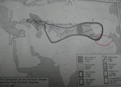
1. The Conquest of the Eurasian Steppes,
2. Turkish Expansion from 950 to the Mongol Conquest,
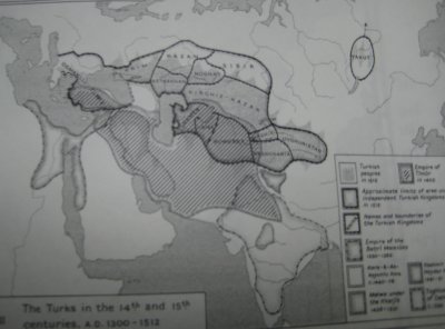
3. The Turks in the 14th and 15th centuries
4. The Age of Ottoman Imperialism,
5. The Turks in History and at the Present Day
6. The Selcuks of Rum
7. The Turkish Emirates, c.
8. Asia Minor and the Aegean Sea,
9. The Emirate of Osman and Orhan,
10. The Conquests of Murad I and Bayezid I,
11. The Ottoman Turks and International Relations,
12. The Civil War,
13. The Recovery of the Empire,
14. Greece and the Aegean Sea
15. Albania
16. The Conquests of Mehmed II and Bayezid II,
17. The Byzantine Empire and the Empire of Mehmed
18. The Raids on the North-west Frontier,
19. The Ottomans and International Relations,
20. The Conquests of Selim
21. The Empire in the reign of Suleyman I,
22. The Campaigns of Suleyman
23. The Empire from 1566 to 1606
24. The Political Divisions of the Empire in 1609 Chart of the Area of the
Ottoman Empire,
25. Anadolu
26. Rumeli
27. Rumeli and Bosna according to Katib-Celebi, c.
28. Dalmatia and Bosnia
29. The Danube Lands
30. The Black Sea and the Northern Steppes
31. Caucasia
32. Syria, Mesopotamia and Kurdistan
33. The Lebanon
34. Egypt and Arabia
35. The Nile Delta
36. The Barbary Coast
地図は23枚目までが年代毎の領域拡大図、24枚目以降が各地州県地図です。
いろいろと発見がありました。
1.オフリ県
昨年12月に読んだ澤井一彰著『オスマン朝の食糧危機と 穀物供給―16世紀後半の東地中海世界 (山川歴史モノグラフ)』のアマゾンレヴュー(こ ちら)に、
【「オフリ県沿岸部」という記述がp222とp241にあるが、オフリ県は現オフリド湖の付近であるため、海岸に面していたのか 疑問(時期により県域は異なると思われるが、ネット上に内陸県となっているオスマン時代の地図がありました)】
と書いてしまいましたが、1525年と1650年の地図ではオフリ県はアドリア海に面していました。内陸県になったのはそれ以降 ということがわかりました。
2.ティール軍が地中海に到達していたこと
ティムール軍の小アジア遠征路が記載されていて、有名な話なのかも知れませんが、はじめて知りました。
3.諸地域詳細地図
コーカサスやシリア・イラクの従属国・直轄領土、アルジェリア沿岸、紅海、南ロシアなどの都市や州区画、行軍図などが、それぞれ A3地図で詳細に描かれているので、本当に詳細で有用。1521/1571/1572/1591年にはモスクワ近郊まで攻め入 り、1571年にはモスクワを陥落させていることも初めて知りました。1987年トルコ製作のオ スマン1世の伝記映画『Kuruluş』で、以下の地図が登場していて、モスクワ大公国も影響圏にあることになって いましたが、一応納得できました。
4.歴史上のテュルク
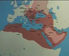
一番面白かった地図は、2枚目の「the turks in history and at the present day」という地図と1枚目のオスマン朝以前の歴代テュルク族王朝地図です。ほるぷ出版社から出ている、トルコ共和国の歴史教科書『トルコ (1981年) (世界の教科書―歴史)』にも載ってない、トルコ民族主義者が喜びそうな地図です(ただし、匈奴は登場していない。 突厥以降の地図となっています)。
最初のこれは、最初のページに4枚掲載されているうちの一枚です。1300年から1512年のユーラシア上のテュルク(トル コ)系王朝の地図。中央アジアの枠線の濃い部分は、モンゴル帝国の後継諸国です。エジプトはマムルーク朝、インドはハルジー朝、 イラン・イラクはティムール朝です。最大領域は、西アジアとインドのほとんどを含んでいることがわかります。
より興味深かったのが、546-946年の地図。中央太枠は突厥。黒海北岸のハザー
ルがテュルク系と
の地図は割と見ますが、エジプトのトゥーラーン朝と、中華王朝五代十国の五代のうち、後唐と後晋(923-946年:赤
線部分)がテュルク系となっています(赤線は私が、強調するために本来の黒線部を赤く着色したもの)。
一番面白かったのが2頁目のこの地図です。これは本来緑と薄緑色の地図です。中央ア
ジアと小アジアの薄緑部分が、現在テュルク系民族が居住している部分。右上は現在のロシア連邦ヤクート共和国のテュルク
人居住範囲。濃い緑部分が、史上テュルク系王朝が支配した領域です。中国黄河中流域からシベリア、中央アジア・インド・
西アジア一帯と、ユーラシア大陸の殆どをかつて支配していたことが端的にわかる地図です。
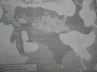
この地図、『テュルクを知るための61章』に載せれば面白かったのではないかと思います。